Ihlet Lifewater Concept
A Cross-Border SDI Approach -- From Local to Global,
July 1-3, 2010 Debrecen, Hungary
Venue: Kölcsey Convention Centre
Ihlet Lifewater Concepts
Pilot The Tisza River Development Program
Background
The Tisza Development Program is initiated by IHLET, a non-profit Research Center of Social, Environmental and Economic Matters, established vis-à-vis the Regional Environmental Technology Center (RETC) in 1998. IHLETs Tisza Development Program is a cross-border initiative, embracing five countries (Hungary, Romania, Serbia, Slovakia, Ukraine see chart 1 below) along the Tisza River. The target area of this regional cooperation is 154.039 km2, with a population of approximately 15.7 million.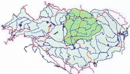
- Environmental protection
- Economic development
- Social development.
This holistic development policy approach reflects the essence of the Johannesburg Declaration whereas only considering these pillars as inseparable can sustainable development achieved.
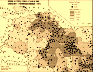
A regional cross-border cooperation along the Tisza River Basin is especially important in light of the more frequent and severe floods, and recent cyanide poisonings and other water quality incidents. The Tisza River Basin area is also the place with several communities living in extreme poverty, the majority of them of Roma origin. Also, in general, this area is economically declining or stagnating, not attracting significant investment and trade opportunities.
The Tisza River Development Program builds on a network of local governments and civil society organizations, including business enterprises and research institutes. The Program is designed to develop the Tisza River Basin area through creating a cross-border spatial data infrastructure for the Tisza River Basin. 80% of data used in public administration is directly or indirectly spatial in nature, e. g. addresses, real property ownership registration numbers, regulatory zones, neighborhood, use of public areas, etc. A harmonized and co-operative utilization and exchange of such data, using the network of IHLET, could increase the efficiency and, thus the impact of managing environmental, social and economic problems.
The Program has three components which are interrelated. First, it aims at establishing an (i) environmental and flood protection system, building on a unified and harmonized River Basin management. This will include the development of a cohesive environmental monitoring system, able to respond to special local requirements and needs, and to take on an essential prevention role, providing timely warnings and action plans.

The Program is a truly cross-border cooperation project, with 48 offices (each office covering approximately 20 local communities) in five countries (see chart 3 above). It builds on the network of local governments and other local players, creating synergies and launching common actions among the five affected countries. The Program is independent from central governments and central budgetary allocations. It uses local government funds and those gained through the economic development component. These funds will then get re-channeled into the social and environmental components.
Relevance of the Tisza River Development Program to the European Commission
-- from the perspective of European Union enlargement and development aid coordination.
The Tisza Development Program of the IHLETs Research Center of Social, Environmental and Economic Matters is a cross-border initiative, embracing five countries (Hungary, Romania, Serbia, Slovakia, Ukraine) along the Tisza River. The programs primary goal is to develop the Tisza River Basin from three perspectives:- Environmental protection
- Economic development
- Social development.
The five affected countries have decided to launch this initiative as a common effort to help improve the life of the communities living along the Tisza River. Technical international agencies, such as the Tisza Committee, The United Nations Development Program (UNDP), The World Bank and the Food and Agriculture Organization (UN/FAO), The United Nations Economic Commission for Europe (UN/ECE), European Organization of Geo-Information (EUROGI), etc., are aware of this initiative and endorse its importance.
From the perspective of the European Commission, this initiative can also be interesting since this is the only region currently in Europe that embraces 3 EU members (Slovakia, Hungary and Romania), 1 Western Balkan Sap (Serbia), and 1 European Neighborhood Policy partner country (Ukraine). This is a unique and intensively complex space/region which condenses the most important legal, environmental, economic and social issues the EC has to and will eventually have to face and resolve. These include, for instance, water poisoning and flood problems, originating from outside of the EU, though affecting the EUs territory. From this perspective, the ECs awareness about this initiative is of ultimate importance.
In addition, three of the five affected countries are new European Union members that pledged to fulfill their commitments as emerging donors. Both Slovakia and Hungary along with the rest of the EU members adopted the European Union Statement on Aid Effectiveness (March 2, 2005) and the European Consensus on Development (November 23, 2005). In these statements, it was stated, national ownership, donor coordination and harmonization, starting at field level, alignment to recipient country systems and results orientation are core principles. Also, the Consensus sets out that the EU will advance coordination, harmonization and alignment.
In sum, this Program could very well demonstrate and/or pilot how three new donors coordinate their development activities not only among each other, but also with the next wave of potential EU members and a European Neighborhood Policy partner country, to achieve higher scale and sustainable results at a coordinated and harmonized fashion. In addition, a true ownership demonstrated by the five countries largely contributes to the expected final positive outcomes.
Technical Aspects Geographic Information Infrastructure for the Tisza River Basin
Component 1
The Tisza River Basin covers an area of about 154.039 square kilometers of five countries (Hungary, Romania, Serbia, Slovakia, Ukraine), with a population of about 15.7 million. In the framework of the IHLET program, the Regional Centre for Environmental Technology has been established by 48 associations at NUTS4 level in the five countries for harmonizing development strategies, planning and running joint projects, and providing common services. The organization is an NGO; its main activities are oriented to prevent future damages of natural and industrial catastrophes, to collect and disseminate data, to channel and transfer environmental innovation, and to assist in co-financing.The environmental needs of the region have generated a comprehensive IT system, focusing on:
- Catalytic effect: Environmental sub-system needs tight co-operation of partners and this tight cooperation enables wider exploitation of common services.
- Interdependencies: An environmental measure depends on and impacts on the economic and social aspects
- Channeling innovation: This common infrastructure makes possible to access metadata and transfer good-practice and applications.
The Tisza River Basin is not just a geographic area but an organic system based on environmental, economic and social analogies and interdependencies. In order to resolve spatial related problems of common interest, an interoperable geographical information (GI) infrastructure is necessary. In November 2000, representatives of the local associations of the five affected countries declared their intention to establish a common GI infrastructure. However, the simple unification of the five countries by itself is unlikely to lead to a common regional level GI system, since it cannot easily solve problems of interoperability, dissemination, access rights, etc. For these reasons, the INSPIRE initiative, and especially the Environmental Thematic User Needs Position Paper, issued by the INSPIRE Environmental Thematic Coordination Group in 2002, is considered the main source to start the technical design of developing a common GI infrastructure for the Tisza River Basin.
Standards and Specifications
The ground is laid by ISO and OGC. The industry adopted numerous new standards. Other standards such as COGI standard for projection and INSPIRE results will be taken into consideration when available.Benefits of a common GI infrastructure for the Tisza River Basin
The main success factors for a common GI infrastructure for the Tisza River Basin can be summarized as follows:- Solving targeted (environmental, economic and social) problems are of great interest for the involved countries.
- The project objectives are relevant for accessing various kinds of EU Funds;National GI Infrastructure is being strengthened in the region.
- Focus is on regional scale and adding value.
- Tools and GI information are becoming more common.
- Synergy with others is a key condition.
- Addresses the needs of the socially excluded.
The GI infrastructure will be managed on three levels:
- Centre - Tisza River Basin Region level:
- Aggregated and generalized data.
- Data to cover gaps of the national GI infrastructure (orthophoto).
- Added subjects: environmental, economic, social.
- Meta data.
- Node Points - National:
- Aggregated and generalized data.
- Access to relevant national level thematic maps.
- Local Offices - Association at NUTS4 level:
- Local large scale data: cadastre, utilities, urban planning, etc.
The motivations to maintain the infrastructure are mainly economic. The Program must recover its costs. In addition, the role and involvement of policymakers at all levels, including mayors and Parliamentarians, are of ultimate importance in order to help prevent and alleviate the risks of potential environmental disasters in the Tisza River basin.
The e-government aspects are of interest at the local level, though they receive limited attention by the local administrations. The private sector will be involved as suppliers of standard and customized GIS and maintainers of the GI data.
Data flow, production, distribution and use
The members of the geographic infrastructure can access their own data, also that at the National Node-points and the Centre. External user can only access the data of the Centre.Data production is not a core business of the Centre and its members, thus it is inevitable to involve national and international GI bodies. Additional GI data could also be gathered by the Centre or by local associations.
Data owned by the members and the Centre will be managed based on copyrights. Local authorities, being members through the local associations, can share data among them; however, external users will be charged for access.
The process of assessing user needs has not yet started. For such, the INSPIRE Environmental Thematic User Needs Position Paper is taken as the starting point and then a second step will be to interview the partners.
Categories of users are three-fold: project (environmental, regional development, etc), member, partner, etc; nature of the user (Local Authority, Utility company, etc).
Strategic goal
To create an international NGO that has unique informatics and telecommunication systems that can serve the protection of Tisza River efficiently and at the same time have a positive effect on the economical development in the region.The consequences and results of the IHLET workshop held in Brussels shows that the IHLET program can become a European and a global pilot.
Conclusions
Conclusion 1.
The Workshop on the IHLET Tisza River Development Programme agreed that the establishment of a regional Geospatial Data Infrastructure is a foundation for- the establishment of a water resources management and an environmental and flood protection system
- the efforts to enhance the region's economic potentials to attract investment and promote trade
- promoting social development in the region, including the social cadastre
Conclusion 2.
The Workshop in recognizing the global nature of the problems to be solved in the Tisza River basin agreed to a close cooperation with other watershed development initiatives in Europe, Africa, Asia and the Americas.Conclusion 3.
The Workshop recognized the importance of the EU INSPIRE Directive as a legal framework for the establishment of a SDI and agreed that the IHLET Tisza River Development Programme should be a pilot for INSPIRE of an implementation of a cross border regional SDI.Conclusion 4.
Geospatial Information should be fully incorporated into- National Development Policies, Strategies and Programmes
- Development Aid Programmes
Recommendations
Recommendations 1.
Supporting the approach "From Local to Global" the participants of the workshop recommend that:- IHLET programme management with the help of the 48 centres and international experts should take the lead in formulating a policy framework taking into account the aspect of environmental protection, economic and social development
- The 48 centres should implement this policy, act as a link to all local communities and contribute to homogeneous and strong institutional ties with their governments
Recommendations 2.
Recognizing the need for an open infrastructure which can be integrated with other applications on a local, regional or national level, the participants of the workshop recommend:- To build the IHLET TISZA River Basin SDI on the emerging INSPIRE standards
- To give priority to establishing a metadata catalogue with a metadata search portal
Recommendations 3.
Recognizing the need for a broad institutional foundation of this project the participants of the workshop recommend that- IHLET should apply to become a member of EUROGI
- All countries of the TISZA River Basin should establish a national organisation for Geospatial Information using IHLET and EUROGI as facilitators